Hard to keep one’s eye on the ball-earth and come to terms with how its geography can be levelled out and presented flat. Globe earth is so complex to render in 2D that we have hundreds of different maps and projections as experts like to label them.
–
Looking back at so-called “historical” maps, it is clear the Elite never meant for the general public to comprehend the design of Earth. The confusing and bewildering graphical representation of all world maps really just say one thing very clearly : the public shall not know the World as it is.
–
We may dislike the fact the Elite wants to explore and use the World according to their own choosing. Reality is, many like to keep any advantage they can get. Wisdom is power and ignorance enslavement – not bliss. Knowing how the real world is designed does quite naturally represent an enormous advantage and absolute territorial control.
–
Nobody can conquer nor rule territories they do not know exist. No riches can be mined from imaginary lands, nor will any virgin soil be discovered travelling on incorrect maps.
–
All territories we’ve ever seen on maps have either already been conquered or were never there to be found. This isn’t magic – it is pure self interest on the behalf of the Elite who has had the means and motivation to keep the World in their own rule and exploit the Earth’s riches to their own benefit since ever.
–

Hand drawn map by Urbano Monte, Milano ca. 1587 – largest known early map of the World. Predictably a perfect North Polar azimuthal projection like the UN flag later
–
Misinformation and false prophets are what the Elite uses to continually confuse and install false belief into the public. We may look back in time and think they were naive back then, but we should take notice the truth still is nowhere to be found. Any straight answer is quickly discarded and replaced with new untruths and more flawed logic.
–
The first step we must make towards better knowledge of Earth is essentially to familiarize ourselves with the plain concept of a level ocean. Water does not bend, curve or stick to a spinning oblate spheroid. Water is flat, and the land that rises above the oceans flatness is nothing else than complex topography that holds plentiful of life.
–

Article : Flat Sea’er
–
Of course, the flatness of water is easy to forget when we look away into the multiverse with solar systems and planets spinning in the vacuum of space. The diversion of astronomy has taken away much genuine interest for the complex system of our seemingly endless surface of flat water and topographic land(s).
–
Understanding how the world is designed requires us to apprehend a base theory about how Earth was brought to become as it appears today. Without light and warmth, Earth clearly would appear like a cold slate or frozen desert of uniform design. Light and heat seem to have changed the dark, uniform, frozen plane into the lively, colourful World we experience today.
–
The most important element to the general layout and design of the known World would therefore be the Sun and its relentless action on the plane we now inhabit. The first and foremost effect of the sun on a cold, frozen slate would be light and heat that would melt matter into solids and liquids – foremost water.
–
Water would first be created according to and onto the Sun’s path. The weight and fluidity of water would on this path exhort great effect and weight onto the thawing ground. Unequal pressure of running water over time will create topography with uneven characteristics. This is what we observe today as the main overarching features of the design and landscape of Earth.
–
The actual sun-path and the Equator are very much complexified on the globe model, but on a planar (flat) design the sun path would be the actual equivalent of the equator. Put simply, what we need to reverse engineer from the globe model is the actual meridian of the equator/sun-path.
–
The estimated sun-path presented graphically on the Mercator projection – the outline shows how the strong forces of the sun over time has pushed land aside and thus demonstrates the propensity for the Son/Sun to divide lands and travel over water
–
From the deduction that the Sun would exert its energy first and foremost along its own path/orbit, it is likely that the forces of water along the sun-path would leave the ground more compact and thus force the ground down, pushing land either inward or outward. In other words, there would be mostly water directly beneath the Sun’s path and more land both inwards and especially outwards of the meridian/sun-path.
–
The actual design of Earth in the Planar model has a well defined centre inside the sun-path meridian, and a corresponding perimeter outside of this central area. The “magic” of the Globe design comes from how Elite Masons have converted both the centre and the perimeter of the planar Earth into two equal parts as Hemispheres.
–

In the graphic hereover we see how the planar model of Earth and the Globe model use actual surface area
–
The common feature of the true Planar Earth model and also the false Globe model is the natural sun-path and equator half way between the poles. The perimeter (outside the equator) of the planar model can be infinite, but the known lands would be limited to the action and effect of the sun. The inner centre of the planar model (inside the equator) would be finite and have a surface area* quite inferior to any hemisphere.
–
If we actually calculate the total surface area of Globe Earth, we find that both hemispheres respectively hold 255 million square kilometres. On the planar model the inner centre (inside the meridian) would be just 127 million km² which is just half the area-size of either hemisphere…
–
The outer perimeter of the Planar model would be very big, with a radius corresponding to the inner centre it would amount to 382 million square kilometres – tree times the size of the centre (inside the equator) of the Planar model, and twice the size of either Globe hemisphere.
–
In order to comprehend how freemasons have managed to make a globe model of a plane surface, we need to understand which of the two hemispheres that has the potential to conjure up the additional 127 million square kilometres that doesn’t exist. The task is actually somewhat more complex than one would expect*, as this major caveat has been a priority to conceal for the Elite Masons.
–
Keeping the equator/sun-path in its actual size (common for both planar and globe models) we can very easily test what hemisphere in the Globe model that deforms the best to fit known, working 2D maps and the Planar model with its reduced centre area and larger perimeter.
–

Mercator map deformed to fit North Hemisphere as Center of Planar model
–

Mercator map deformed to fit South Hemisphere as Center of Planar model
–
Can you see what is obvious here-over ?
–
Only one of the two deformations makes sense on both hemispheres simultaneously. Sizes and surfaces are not exact but the shape and design is. The authors of the Globe model have needed all the confusion they could master conjure in order to hide the obvious fact there is too much water on the South hemisphere, and too much land on the North hemisphere for anyone to even wonder where the centre of a theoretical flat Earth map would have to be : The non-existing South Pole…
–
What is quite remarkable here is of course that even all the early cartographers did their best to conceal the true design of Earth as they all place the North Pole at the centre of their designs. All informed mapmakers have thereby always been in on the plan to hide the Earth’s true geography from the general public…
–
The actual reason we today have the Globe model is the fact the spherical model works better than the inverted flat version of of Earth centered on the North Pole. This early design is too obviously false when examined – like the Urbano Monte map and other North Polar azimuthal projections.
–
The Globe offers much better odds at fooling the public over time than the inverted flat Earth design based North like in the early days. The Globe model provides better surface area management, and the use of a sphere ensures uncountable projective interpretations where none is better than the next.
–
In order to seal the deal on deceiving the general public about the actual design of Earth, it’s vacant soils and hidden treasures – the Elite needed to discover the American continent in order to fill in blanks and create a more credible design of a Globe… So, yes there is more land. Only we just barely know what is misrepresented on the false Globe model.
–
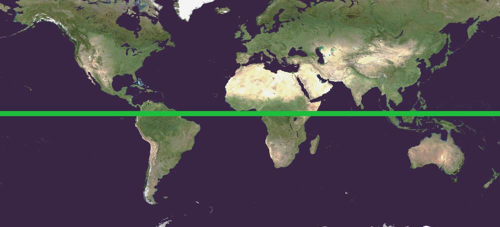
The amount of land & ocean above and below Equator (green)
–
From the Mercator map above we can clearly see how there is more land the further North we go. Likewise there is more water the further south we go. As the Globe model of Earth is incorrect, the only way to make a Globe map work would be to make up inexisting space where the center of a planar model is, and reduce the size and access to land where the perimeter would be.
–
It is very important therefore to establish how it is possible to have two equal hemispheres in the Globe model despite the obvious hinderance of the center of a flat, circular map being much smaller in surface area. In order to expand the total area contained in the center of a circular layout (inside the equator), we need to add either land or water. On the contrary, we would have an external perimeter in a flat model (ouside of the equator) that would contain much more surface area than the corresponding hemisphere on a globe.
–
The most obvious give away therefore when looking at the Globe model would be how one hemisphere would need to add inexisting surface area, while the other hemisphere would have the opposite problem of too much land… There are only two ways to add more land to hemisphere on the Globe model, more landmasses or more oceans.
–
Adding landmasses that do not exist would be very hard as we live on land and have the ability to survey landmasses relatively well. On the other hand, adding ocean surface area that do not exist would be easy as we have no way to effectively survey water – the oceans remain largely untravelled and uninhabited. In other words, if we were to choose between creating fake landmasses and fake water bodies, there would not be much of choice. The missing surface area would be hidden by adding water bodies.
–
Creating 127 million supplementary square miles of water in the Northern Hemisphere would be impossible. Adding more water to the Southern Hemispher would be easy. And once you look closely it really shows that water has indeed been added down South. Because South is Center…
—
* the surface area of a plane circle is expressed as Πr², and the surface area of a hemisphere is expressed as 2Πr²
–
* hiding 127.000.000 km2 is however not hard enough for all FE researchers to ignore for so many years – which easily explains how a vast number of people actually have conspired to fool us over and over – all FE researchers included
–
* the Mercator projection (1569) deforms both hemispheres the same manner – a true size equator with grossly stretched polar areas
South is Center
Published
https://shorturl.fm/rVSgm